 |
||||
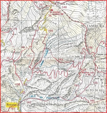
| From the parking lot (terminal stop for bus #78 to Resceto),
take the paved road on the left that goes uphill. Follow the CAI red and
white markings on path #35. After a while you will be able to see the
Via Vandelli snaking up the mountains ahead of you. Cross the river on
an iron bridge (small building on left with park information display).
Continue on this path, there will be a small chapel on the right about
halfway up, then at elevation 1250 there is an old iron mine on the left.
Continue on the main path #35 uphill. After more hairpin turns you reach
a junction, take the right path to the refugio, the left one leads up
to Mount Tambura. After reaching a small, flat open area created to allow
stage coaches to stop, follow the path to the left through the Campaniletti
steeples and in about 5 min a cold drink is available at the refugio.
|
||||
| Hike rating: | ||||
| Beauty | awesome views, alpine plants, historic path | |||
| Difficulty | moderate to difficult, 3000 feet elevation gain, limited shade | |||
| Time | up | 2.5 to 3 hours from Resceto | ||
| down | 2 hours | |||
| Home
| Cinque Terre | Alpi
Apuane | Tuscany
| Resources | Links
Click the links above to see more information about each region or the link below to return to our HomePage Main Page with links to hiking and cycling information in other areas |